
Jacksonville, Fl. — THE TROPICS:
***** ALWAYS CHECK & RE-CHECK THE LATEST FORECAST & UPDATES! ****
Tropics threats/impacts for Jacksonville/NE Florida/SE Georgia: None
The Atlantic Basin Overview:
The Atlantic hurricane season is June 1st through Nov. 30th.
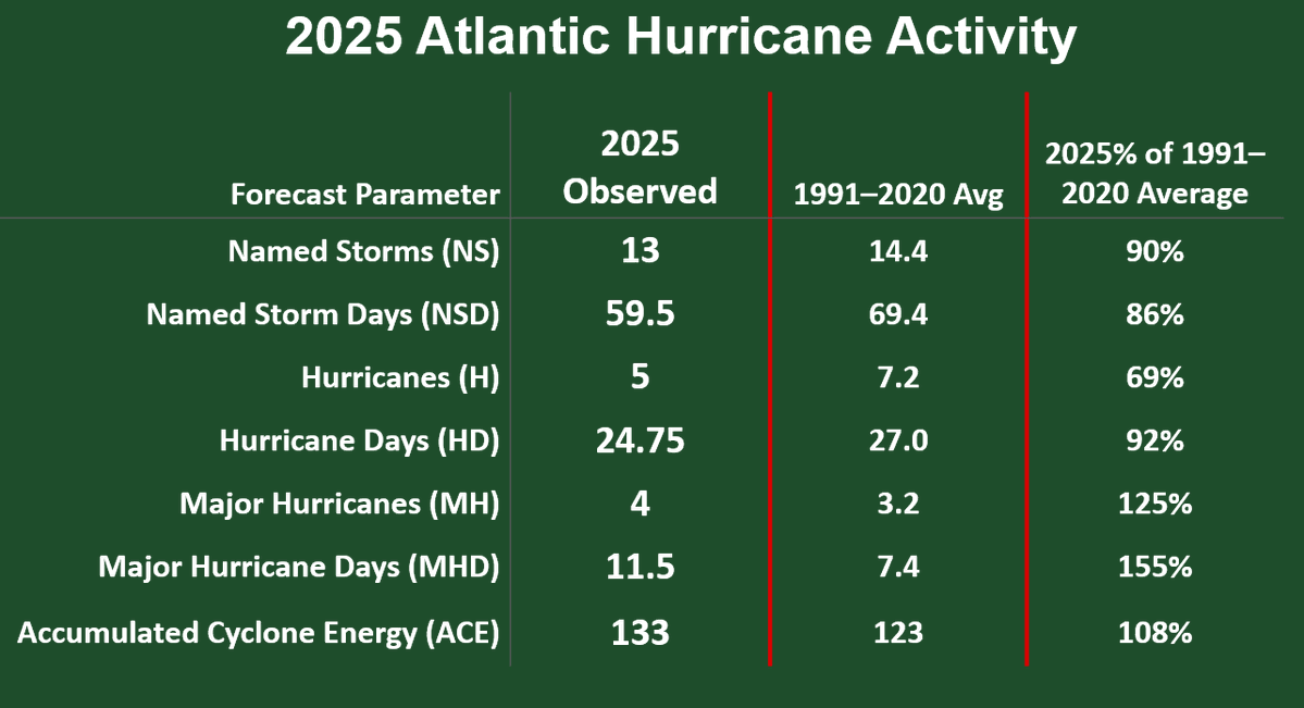
Dr. Phil Klotzbach, Colorado State University (ACE=The phrase “total overall seasonal activity” refers to the combined intensity and duration of Atlantic named storms and hurricanes occurring during the season):
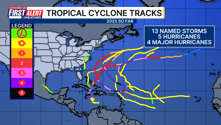
The 2025 hurricane season will be remembered for:
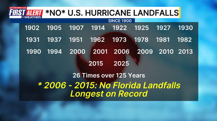
(1) no U.S. hurricane landfalls for the first time since 2015

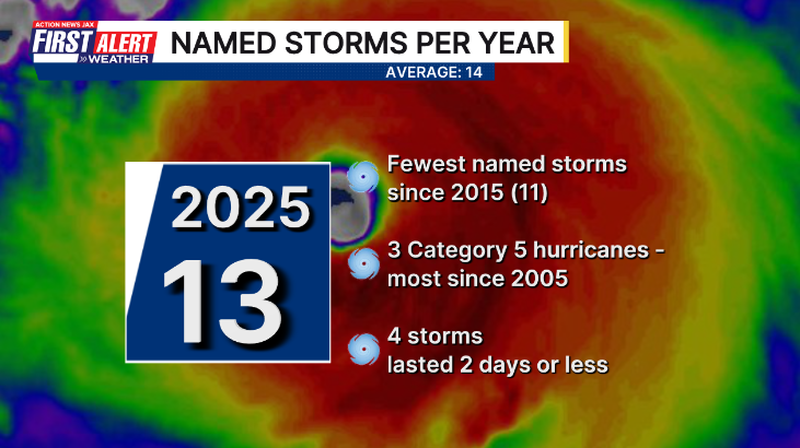
(2) “only” 5 hurricanes but 4 became Cat. 3+ & 3 were Cat. 5
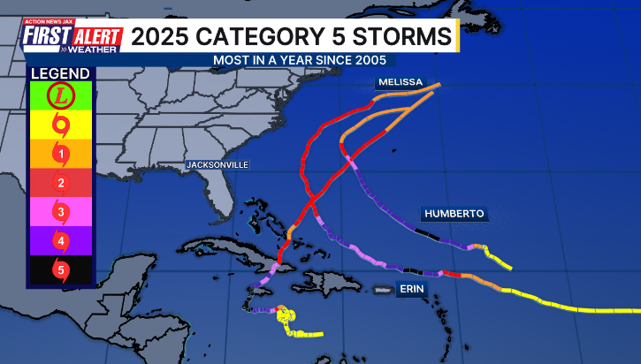
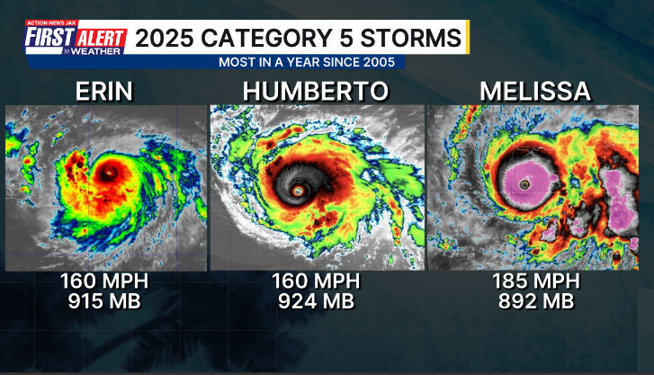
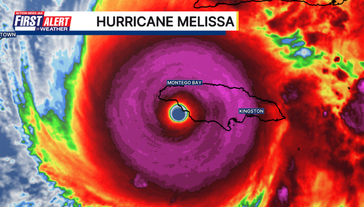
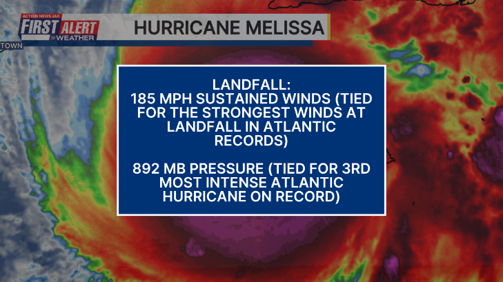
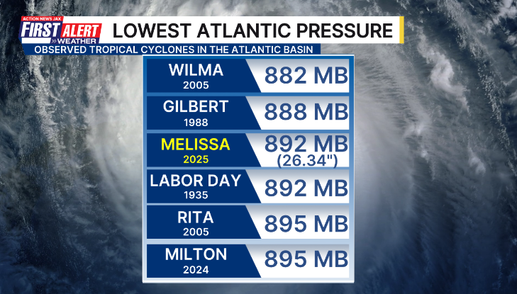
(3) “Melissa” - the most violent hurricane of the 2025 season making a devastating landfall on the southwest coast of Jamaica.
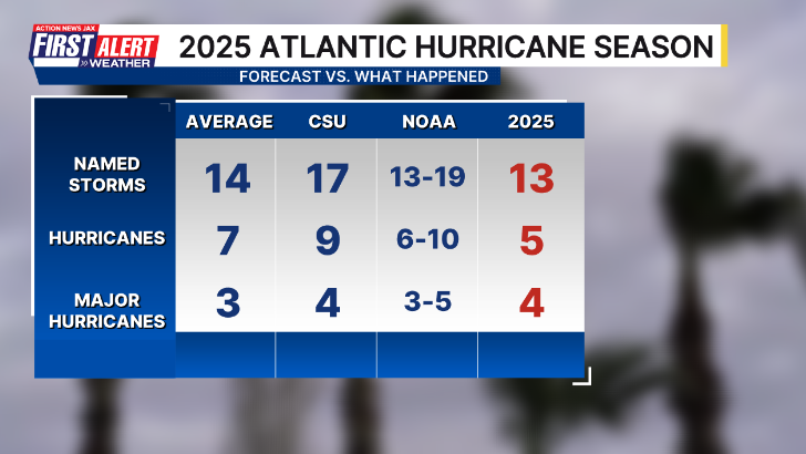
Preseason forecasts were generally a little high on seasonal forecasts but not by a lot.
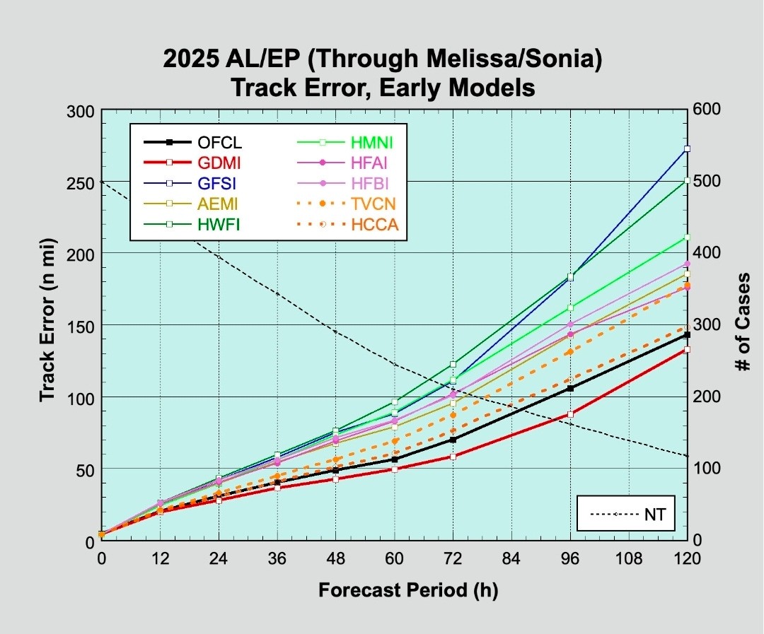
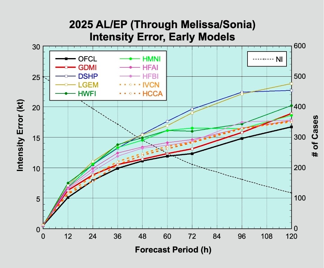
As for the forecast models & the National Hurricane Center forecasts, there was a wide range in accuracy. For the first time, Google Deep Mind was available publicly & became operational & did very well as a whole, especially on track forecasts. The National Hurricane Center had a very good season on track & particularly on the chronically difficult intensity forecast (images below for E. Pacific & Atlantic tropical cyclones) while the American GFS model struggled mightily:
Month by month Atlantic Basin breakdown for 2025:
JUNE
24th - the first named storm - “Andrea” formed over the North Atlantic & dissipated the same day.
29th - Tropical storm “Barry” formed over the Southwest Gulf & made landfall the same day in Eastern Mexico as a tropical depression.
JULY
5th - Tropical depression#3 formed over the West Atlantci & became tropical storm “Chantal”.
6th - Tropical storm “Chantal” landfall in South Carolina south of Myrtle Beach.
AUGUST
23rd - Tropical storm “Fernand” formed over the Southwest Atlantic and became a Cat. 4 the same day!
28th - Last “Fernand” advisory over the North Atlantic
SEPTEMBER
17th - Tropical storm “Gabrielle” formed over the Central Atlantic... became a hurricane on the 21st.. & a Cat. 4 on the 22nd.
24th - Tropical storm “Humberto” formed over the Central Atlantic.
25th - Last “Gabrielle” advisory over the North Atlantic
27th - “Humberto” became a Cat. 5 over the Central Atlantic... dissipated Oct. 1st
27th - Tropical depression #9 formed southwest of the Bahamas
28th - T.D. #9 becomes tropical storm “Imelda” & hit Bermuda as a Cat. 2 before dissipating Oct. 2 (early model forecasts had this storm much closer to the Southeast U.S. which did not end up being the case).
OCTOBER
7th - Tropical storm “Jerry” formed over the Central Atlantic & dissipated on the 11th
9th - Subtropical storm “Karen” formed over the Northeast Atlantic & dissipated the next day on the 10th
13th - Tropical storm “Lorenzo” formed over the East Atlantic... last advisory/dissipated on the 15th
21st - Tropical storm “Melissa” formed over the Eastern Caribbean
25th - “Melissa” became a hurricane over the Caribbean... reaching Cat. 5 intensity on the 27th.
28th - Cat. 5 “Melissa” landfall on the southwest coast of Jamaica
29th - “Melissa” Cat. 3 landfall Southeast Cuba... Cat. 2 landfall in the Bahamas
31st - Last “Melissa” advisory over the North Atlantic
NOVEMBER
No Atlantic named tropical cyclones.
During this last week of the hurricane season, no areas of concern across the Atlantic, Gulf & Caribbean.


‘Velocity potential anomalies’ below. shows “Rising” air (green lines) equates with an uptick in overall convection. With rising air, conditions are generally more favorable for tropical development. Where there are brown lines, the air is generally sinking & is often less conducive to tropical cyclones (though not impossible to have development).

The “Buresh Bottom Line”: Always be prepared!.....First Alert Hurricane Preparation Guide... City of Jacksonville Preparedness Guide... Georgia Hurricane Guide.
STAY INFORMED: Get the * FREE * First Alert Weather app
FREE NEWS UPDATES, ALERTS: Action News Jax app for Apple | For Android
WATCH “Preparing for the Storm”
WATCH “The Ins & Outs of Hurricane Season”
READ the First Alert Hurricane Center “Preparation Guide”
LISTEN “First Alert Weather: Preparing for the Storm”
Federal Alliance for Safe Homes (FLASH) * here *.
REMEMBER WHEN A TROPICAL STORM OR HURRICANE IS APPROACHING: Taping windows is *not* recommended & will not keep glass from breaking. Instead close curtains & blinds.
Realize the forecast cone (”cone of uncertainty”) is the average forecast error over a given time - out to 6 days - & *does not* indicate the width of the storm &/or where damage might occur.

The map below shows the *average* time for a tropical wave coming off Africa to travel west & northwest. Only about 1 in 5 tropical waves - on average - become a tropical cyclone of some sort (depression/storm/hurricane):


Water vapor loop (dark blue/yellow is dry mid & upper level air):


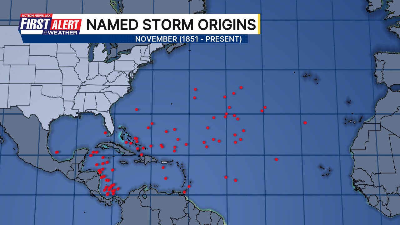
November Atlantic tropical cyclone origins:
Averages below based on climatology for the Atlantic Basin for November:

Wind shear (red - strong shear; green - low shear). Shear is typically strong to start the hurricane season:


Saharan dust spreads west each year from Africa driven by the prevailing winds (from east to west over the Atlantic). Dry air = yellow/orange/red/pink. Widespread dust is indicative of dry air that *can* interfere with the development of tropical cyclones. However, sometimes “wanna’ be” waves will just wait until they get to the other side of - or away from - the dust plume then try to develop if other conditions are favorable (we saw this with Beryl & Debby last year). It’s my personal opinion that there is way too much “hoopla” about the presence of Saharan dust & how it relates to tropical cyclones. In any case, the peak of Saharan dust typically is in June & July, & we are indeed seeing a large “blobs” of Saharan dust over the Central & Eastern Atlantic that’s thinning with westward extent but enough of it to make for hazy skies across the Caribbean & - at times - across parts of Florida.

2025 names..... “Nestor” is the next name on the Atlantic list (names are picked at random by the World Meteorological Organization... repeat every 6 years). Historic storms are retired [Florence & Michael in ’18... Dorian in ’19 (the last time this year’s list was used) ... Laura, Eta & Iota in ‘20 ... Ida in ‘21 ... Fiona & Ian in ‘22... no names were retired in ‘23 for the first time since 2014... & Beryl, Helene & Milton last year in 2024]). The WMO decided - beginning in 2021 - that the Greek alphabet will be no longer used & instead there will be a supplemental list of names if the first list is exhausted (has only happened three times - 2005, 2020 & 2021). The naming of tropical cyclones began on a consistent basis in 1953. More on the history of naming tropical cyclones * here *.

Hurricane season climatology:


East Atlantic:


Mid & upper level wind shear (enemy of tropical cyclones) analysis (CIMMS). The red lines indicate strong shear:

Water vapor imagery (dark blue indicates dry air):

Deep oceanic heat content over the Gulf, Caribbean & tropical Atlantic. Brighter colors = warmer temps.:

Sea surface temps.:

Sea surface temp. anomalies:

SE U.S. surface map:

Surface analysis centered on the tropical Atlantic:

Surface analysis of the Gulf:

Caribbean:

Atlantic Basin wave period forecast for 24, 48, 72 & 96 hours respectively:


This past spring I visited the west coast of Florida - from Cedar Key to Tampa Bay - to see how the area is recovering from the very rough ‘24 hurricane season namely Helene & Milton:
East & Central Pacific:


Central Pacific:

Hawaii satellite imagery:


West Pacific:
Global tropical activity:


Cox Media Group