
Jacksonville, Fl. — The “Buresh Bottom Line”: Always be prepared!.....First Alert Hurricane Preparation Guide... City of Jacksonville Preparedness Guide... Georgia Hurricane Guide.
STAY INFORMED: Get the * FREE * First Alert Weather app
FREE NEWS UPDATES, ALERTS: Action News Jax app for Apple | For Android
WATCH “Preparing for the Storm”
WATCH “The Ins & Outs of Hurricane Season”
READ the First Alert Hurricane Center “Preparation Guide”
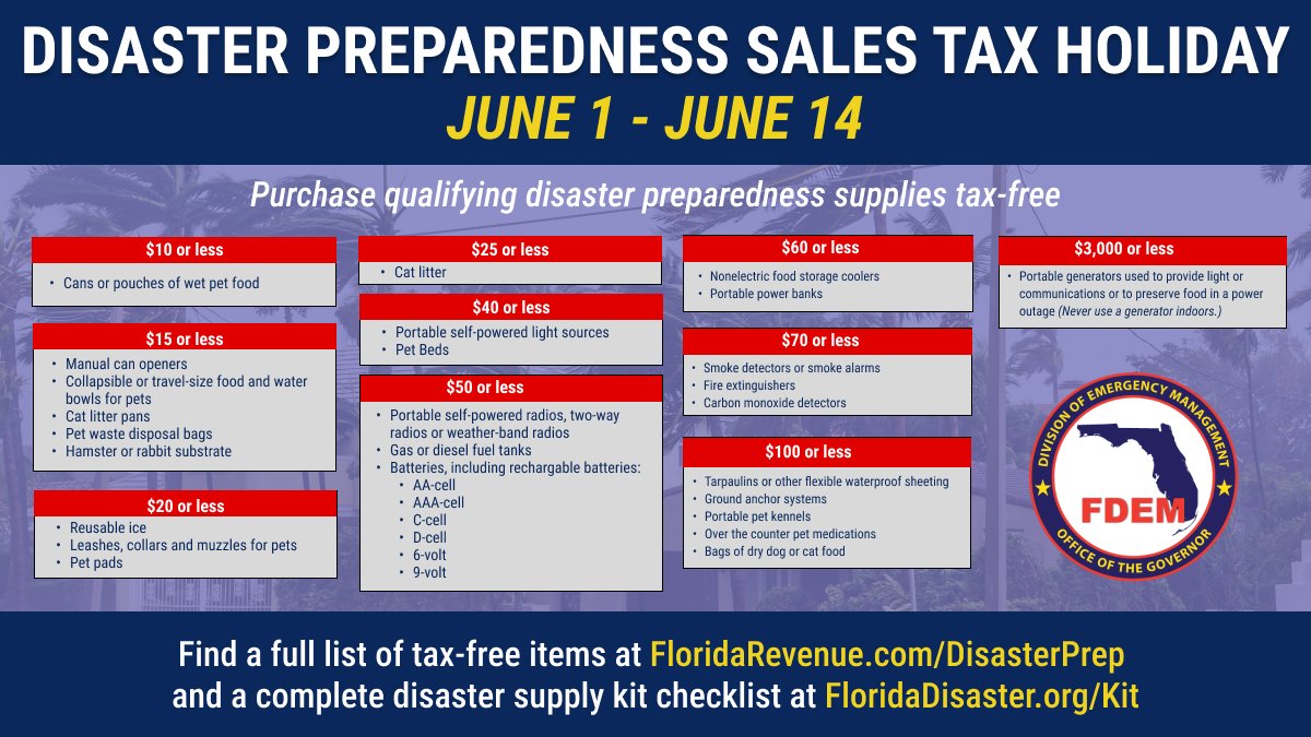
Through June 14th:
***** ALWAYS CHECK & RE-CHECK THE LATEST FORECAST & UPDATES! *****
REMEMBER WHEN A TROPICAL STORM OR HURRICANE IS APPROACHING: Taping windows is *not* recommended & will not keep glass from breaking. Instead close curtains & blinds.
Realize the forecast cone (”cone of uncertainty”) is the average forecast error over a given time - out to 5 days - & *does not* indicate the width of the storm &/or where damage might occur.

*** LOCAL (Jacksonville/NE Fl./SE Ga.) IMPACTS FROM THE TROPICS: None through this weekend.
The Atlantic Basin Overview:
There are no active storms & no tropical development is expected into the weekend.
There continues to be a persistent area of convection over the SW Atlantic extending into the Central Atlantic associated with an upper level trough of low pressure that’s developing weak low pressure at the surface. This feature is expected to drift east/northeast over the open Atlantic with little chance for tropical development though there could be some subtropical characteristics if the low can remain over warmer water while nowhere near any land areas.
Of *POSSIBLE* interest is the potential development of low pressure near Florida & over the Gulf of Mexico during the early to middle part of next week. The European forecast model is not onboard so far (but does show an increase in disorganized shower & t’storm activity) while the Canadian forecast model (CMC) still occasionally pops low pressure at least somewhat similar to the GFS model. So the GFS model continues to show some low pressure over the Central or Eastern Gulf. The model has been inconsistent in the details - no surprise - but has been quite persistent in indicating development. Chances appear low right now for true tropical development next week, but it’s an area to keep an eye on. If nothing else, it does look like there will be a surge of tropical moisture northward across Florida increasing daily rainfall - much needed in what has been a sluggish start to the wet season.


The season is forecast to be active largely predicated on unusually warm ocean temps. & a likely-to-develop La Nina (cooling of the equatorial Pacific which often correlates with less shear across the Atlantic Basin):

The upper oceanic heat content (UOHC) [tropical cyclone heat potential/TCHP] across the SW Atlantic, Gulf & Caribbean is unseasonably high for this time of year:


Water vapor loop (dark blue/yellow is dry mid & upper level air):


June tropical cyclone origins (early season breeding grounds are the Gulf &/or Western Caribbean:

Averages below based on climatology for the Atlantic Basin for November (7 hurricanes so far, 19 tropical storms):
Wind shear (red - strong shear; green - low shear):


Saharan dust spreads west each year from Africa driven by the prevailing winds (from east to west over the Atlantic). Dry air = yellow/orange/red/pink. Widespread dust is indicative of dry air that *can* interfere with the development of tropical cyclones. However, sometimes “wanna’ be” waves will just wait until they get to the other side of - or away from - the dust plume then try to develop if other conditions are favorable. In my personal opinion, there is way too much “hoopla” about the presence of Saharan dust & how it relates to tropical cyclones. In any case, the peak of Saharan dust typically is in June & July.

2024 names..... “Alberto” is the first name on the Atlantic list (names are picked at random by the World Meteorological Organization... repeat every 6 years). Historic storms are retired [Florence & Michael in ’18 (the last time this year’s list was used)... Dorian in ’19 & Laura, Eta & Iota in ‘20, Ida in ‘21 & Fiona & Ian in ‘22]). In fact, this year’s list of names is rather infamous because of the ‘04 season when Charley, Frances, Jeanne & Ivan - all retired names - hit Florida within a matter of about 6 weeks. The WMO decided - beginning in 2021 - that the Greek alphabet will be no longer used & instead there will be a supplemental list of names if the first list is exhausted (has only happened three times - 2005, 2020 & 2021). The naming of tropical cyclones began on a consistent basis in 1953. More on the history of naming tropical cyclones * here *.


East Atlantic:


Mid & upper level wind shear (enemy of tropical cyclones) analysis (CIMMS). The red lines indicate strong shear:

Water vapor imagery (dark blue indicates dry air):

Deep oceanic heat content over the Gulf, Caribbean & deep tropical Atlantic. The colors will brighten greatly as the water warms to greater depths deeper into the season:

Sea surface temp. anomalies:


SE U.S. surface map:

Surface analysis centered on the tropical Atlantic:

Surface analysis of the Gulf:

Caribbean:

Atlantic Basin wave period forecast for 24, 48, 72 & 96 hours respectively:


East & Central Pacific:


West Pacific:

Global tropical activity:


Cox Media Group
 Sign Up

